Coastal Management
-
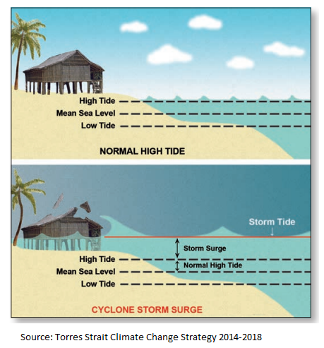
There are two common coastal hazards under the present climate:
Coastal erosion:
Erosion occurs when winds, waves and coastal currents act to shift sediments away from an area of the shore, often during a storm. In most locations this is a short-term process and the shore gradually regains sediment.
Inundation:
During a storm, low atmospheric pressure and onshore winds can cause storm surge and extreme wave heights along the coast. When these coincide with high tide, inundation may result.
Coastal hazards can result in property damage, loss of life and/or environmental degradation. The impacts are generally greatest where the shoreline has been modified and development for infrastructure or settlements.
(Source: Coastadapt.com.au)
As our climate changes, the impacts, locations and frequency of coastal erosion and inundation are also anticipated to change, particularly due to rising sea levels.

-
-
The CHAS guides decision-making across key areas of local government planning and operations including:
• Corporate and operational planning and financial planning
• Land use planning and development assessment
• Infrastructure planning and management including roads, stormwater and foreshores
• Asset management and planning including nature conservation, recreation, cultural heritage values and other public amenities
• Community planning
• Emergency management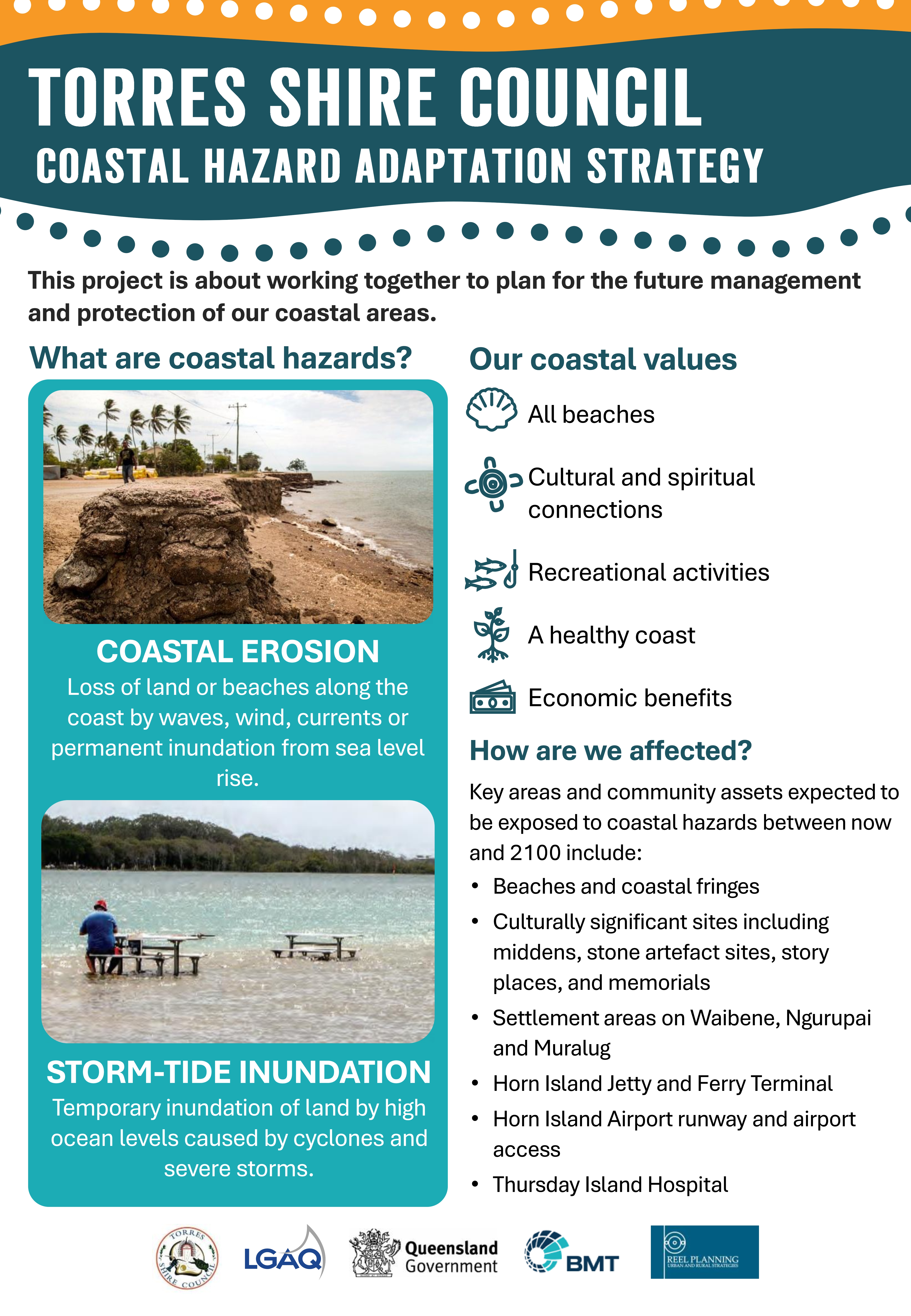
-
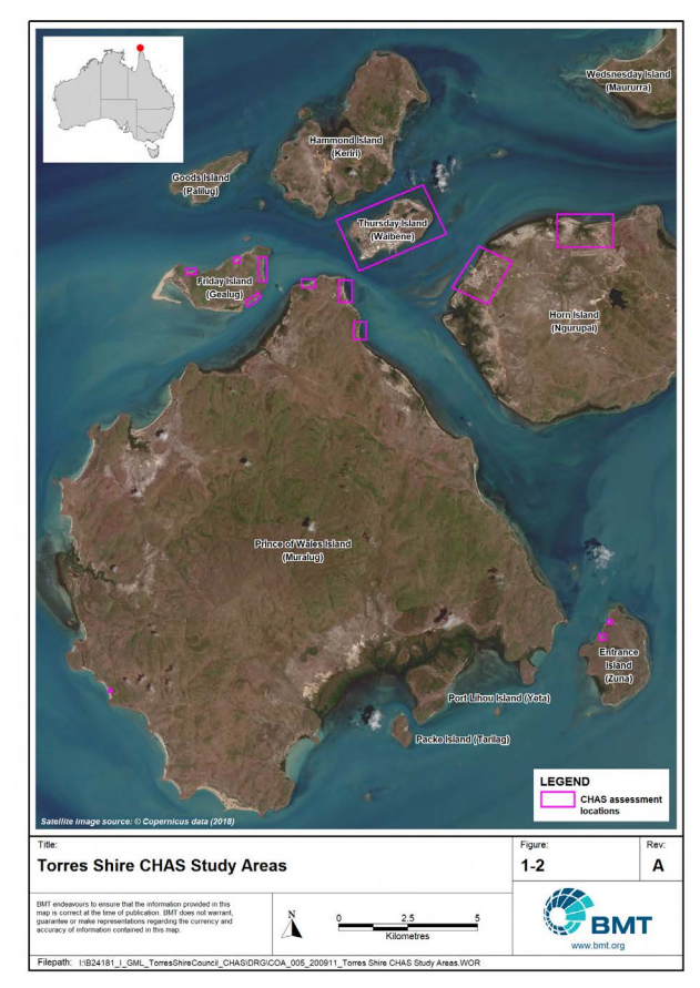
The focus of the CHAS is on the coastal settlements of Torres Shire, namely:
• Waibene (Thursday Island) – entire coastline
• Ngurupai (Horn Island) – Wasaga township and the coastline seaward (north) of the airport
• Muralug (Prince of Wales Island) – Front Beach (Community of Muralug), Country Women’s Beach and Collis Beach
• Gealug (Friday Island) – Pearl farm site on the south-eastern corner of the island, as well as three additional settlement areas on the norther and eastern coastlines
• Zuna (Entrance Island) – Two settlement areas along the north-western coastlineMap of locations of interest for CHAS
-
Phase 1 – Plan for communication and engagement
- Preparation of a Stakeholder Communication and Engagement Strategy which identifies:
- the project reference group
- key stakeholders
- how Council will engage and keep the community involved and informed
Status: Complete
Phase 2 – Scope coastal hazard issues
- Preparation of the Torres Shire Coastal Hazard Risk, Vulnerability and Adaptation Assessment which identifies the potential risks to the community, assets and values associated with coastal hazards, specifically:
- temporary flooding of coastal areas due to storm tide
- temporary loss of land due to coastal erosion
- permanent loss of land due to coastal erosion and sea level rise
- Planning horizons adopted for the CHAS are present climate, 2050, 2070 and 2100
Status: Complete
Phase 3 – Identify areas exposed to current and future coastal hazards
- Engage with the key stakeholders and the community to:
- Inform them about the project
- Identify opportunities for them to be involvement
- Obtain views and feedback about what they value about the coast
Status: Complete
Phase 4 – Identify key assets potentially impacted
- Undertake technical assessment to identify the key social, cultural, economic and environmental assets exposed to coastal hazards. The assessment considers storm tide, sea level rise and erosion hazard extents and inundation depths determined in Phase 3 of the CHAS for the present climate, as well as 2050, 2070 and 2100 future climates.
Status: Complete
Phase 5 – Undertake risk assessment of key assets
- Undertake a Risk Assessment which describes the risk to assets potentially exposed to coastal hazards. Specifically, the analysis focuses on the development of a tailored risk assessment framework applied to key assets potentially exposed to coastal hazards for the present climate (i.e. short-term), and medium- to long-term (nominally years 2050 and 2070 to 2100) projected future climates.
Status: Complete
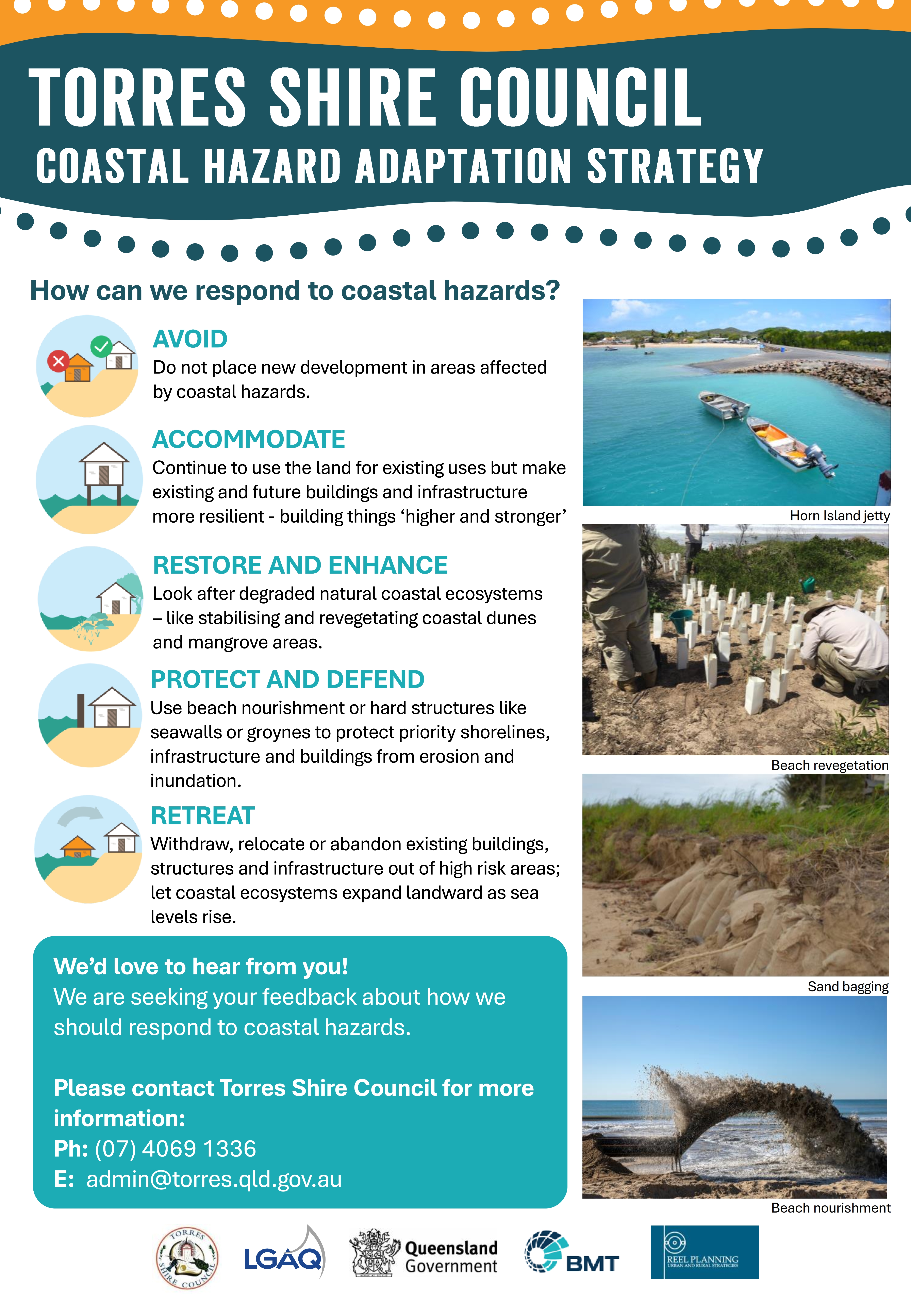
Phase 6 – Identify potential adaptation options
- Identification and documentation of potential adaptation options for considered at each location to treat the High or Extreme risks identified in Phase 5. This stage involves extensive community engagement to:
- Provide an update on project
- Share findings from technical work and consultation to date
- Present and gain feedback on the adaptation options being considered
- Identify the next steps involved in the Torres Shire CHAS
Status: Complete
Phase 7 – Appraise adaptation options
- Undertake more detailed analysis of potential adaptation options using a range of social, environmental and economic criteria. This will support council’s decision-making when selecting the final preferred option or suite of options to respond to identified risks and meet the outcomes sought.
Status: Complete
Phase 8 – Strategy development, engagement, implementation and review
- Collate and summarise all the findings of previous phases and to develop a final Strategy document. The Strategy provides the overarching strategic direction and framework for a coordinated and integrated ‘whole of council’ response to coastal hazard adaptation. It is an important means of guiding change, informing decision making and prioritising actions across the organisation to respond to current and future coastal hazard risks.
Status: Complete
- Preparation of a Stakeholder Communication and Engagement Strategy which identifies:
-